Editor's Note: You simply must go to this wonderful new website to see the San Francisco Bay that might have been HERE . It is a wonderful tribute to the gallant efforts of people to save our treasured county. It is a positive crime that the same forces of urbanization are being championed by Steve Kinsey, Kate Sears and Katie Rice under the false flag of environmentalism. Plan Bay Area imposes rapid urbanization of Marin and the other counties in the Bay Area. These are just a few of the stories. We will Save Marin Again!
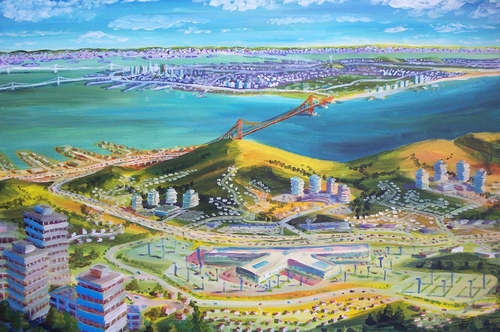
Marincello: Invisible City
Marincello may be the iconic example of “what might have been”. Instead of miles of hiking trails, epic vista points, and the occasional bobcat or hawk sighting, one could find themselves standing amongst cul-de-sacs ringed by multiple-car garages and private backyards.
Such was the aim of Marincello, a planned community for 25,000 residents on 2,100 Headland acres proposed in 1964 by Pittsburgh developer Thomas Frouge. The plan included model homes, a mile-long mall, and central high-rise hotel. Financially backing the project was Gulf Oil.
Support for the plan came from local newspapers and on November 12, 1965, the Marin County Board of Supervisors approved the Marincello plan. According to John Hart: “Three attorneys labored on this seemingly lost cause: Robert Praetzel of San Rafael, and Martin Rosen and Douglas Ferguson of Sausalito… ‘I got involved not so much for an environmental purpose as a civic
purpose,’ says Rosen, later a founder of the Trust for Public Land. ‘I just felt it was terrible that these few people could turn around an entire landscape, and not even consult the local citizens. I was more Jeffersonian than Thoreauvian.’ ”
Construction in Tennessee Valley. Praetzel, Rosen, and Ferguson skillfully maneuvered and brought suits against the development company on grounds of process, and progress to build Marincello ceased in 1967. Public opinion began shifting in opposition of the plan. Thousands of petition signatures were gathered.
Then, on November 2, 1970, a state appellate court ruled that Frouge and the developers had violated process, and their plan would have to be submitted all over again.
According to Doug Ferguson in the “Rebels With a Cause” documentary, Gulf Oil’s attitude was that they could keep the litigation running for years, causing the “conservationists” to run out of money. But, Doug notes, there was something Gulf Oil didn’t understand. “[Those fighting Marincello] are unpaid—and they’re crazy.” Praetzel alone estimates he volunteered over 1,000 hours of his time.
Meanwhile, Huey D. Johnson, then Western Regional Director of The Nature Conservancy, had started pressing Gulf Oil. He visited their headquarters time and time again, pressing for them to give up the battle. He would get laughed out of the boardroom.
At the end of 1972, Gulf Oil capitulated and sold the Marincello site for $6.5 million dollars to the Conservancy. The area was re-named Gerbode Valley and later transferred to the National Park Service for the newly-forming Golden Gate National Recreation Area.
All that remains of the battle is the fire road constructed for development. It is now used as a train, and from its highest point, one can see public, open space for miles in all directions.
Where to learn more:
Marincello UnSoundwalk is a project by local artist Aaron Ximm: http://www.quietamerican.org/related.html
“Saved by Grit and Grace”, Bay Nature article written by John Hart http://baynature.org/articles/saved-by-grit-and-grace/
Resource Renewal Institute is a nonprofit founded by Huey D. Johnson. His project, “Forces of Nature: Environmental Elders Speak” is a collection of interviews with Bob Praetzel and others. http://theforcesofnature.com/movies/robert-praetzel/
“Rebels With a Cause” is an excellent documentary about Marincello and other defeated projects. http://rebelsdocumentary.org/trailer/
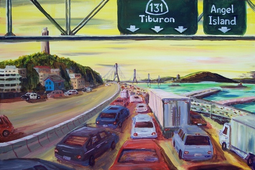
Tiburon Bridge: Linking Telegraph Hill to Angel Island
The San Francisco-Oakland Bay Bridge opened in 1936. Golden Gate Bridge began connecting San Francisco to lands north in 1937. By the mid-1940s, planners were at work imagining other possible Bay crossings to respond to increasing automobile traffic.
Proposals included a twin Golden gate Bridge, an underwater tube between Aquatic Park in San Francisco and Sausalito in Marin, and several bridge designs linking lands south and north via Angel Island, an uninhabited landmass in between. Nearly a dozen additional crossings were also proposed linking San Francisco to Oakland and Alameda to the east.
In the 1960s the federal government proposed transferring Angel Island to the state, making the option for a Tiburon Bridge and new freeway up the Tiburon Peninsula seem possible. The bridge would have exited San Francisco from either Telegraph or Russian Hill, two of the city’s oldest neighborhoods. California’s Highway Department (CalTrans) acquired State Route 131 in Tiburon as the planning advanced.
According to an interview with Harold Gilliam, who was working with the US Department of Interior at that time, then-Interior Stewart Udall devised a condition in the Angel Island transfer that stipulated that if the island be used for any infrastructure purpose that it would revert back to the feds. This meant: no bridge.
According to “Bridging the Bay”, a project out of UC Berkeley: “That none of these various schemes came to pass can perhaps best be attributed to a general lack of public consensus over choosing a route that made sense financially and environmentally. Today, over a half century later, consensus remains elusive, and, in the near term, a renewal of ferryboat fleets on the Bay seems more likely than any grand scheme to cross its waters with additional bridges.”
Where to learn more:
Interview clip with Harold Gilliam, via FoundSF:http://foundsf.org/index.php?title=Freeways_trashed_by_89_quake
UC Berkeley Library, “Bridging the Bay” Primary Source page with newspaper clippings:http://www.lib.berkeley.edu/news_events/bridge/up002.html
Information on San Francisco’s “Freeway Revolt” of the mid-1950s:http://www.cahighways.org/maps-sf-fwy.html
Marin Highway System: The “Los Angelization” of the Bay Area?
Before the Golden Gate Bridge opened in 1937, accessing the lands north of San Francisco required ferries, trains, and a bit of gumption. With the bridge complete, what had been ranch lands soon were considered for networks of mid-century suburban sprawl.
In 1958 Governor Pat Brown launched an ambitious statewide highway development project, on the promise of building 1,000 new miles of road. This plan included 200 miles of new coastal and cross-cutting highways in Marin and Sonoma. All of this was laid out in the 1964 West Marin General Plan, a “nightmare vision for Marin conservationists.”
The plan prescribed turning the two-lane Highway One along the coast into a four-lane parkway, and to cut across ridges from Point San Quentin to Point Reyes Station with east-west thoroughfares. A 1959 Army Corps of Engineers report estimated that as facilitated by the highways, Marin would grow from 151,000 in 1960 to 780,000 by 2020. Stinson Beach and Bolinas Ridge would balloon to 50,000 residents. Point Reyes, Limantour, and Tomales would host a staggering 150,000 people. A water pipeline from Sonoma would feed the suburban sprawl.
As Dr. Marty Griffin writes in “Saving the Marin-Sonoma Coast”: “By coincidence perhaps, [Governor Brown’s] chief of advance freeway planning for the state was Harold Summers, whose wife, Mary, headed the Marin County Planning Department.” By 1961 the Board of Supervisors in Marin had adopted the plan, with Mary Summers calling it a “done deal”. There seemed little in way of hope.
Dr. Marty Griffin and Stan Picher of Marin Audubon Society decided to try the impossible: save Bolinas Ridge, and by doing so, block the path of the highway. Achieving this could save Bolinas Lagoon, Stinson Beach, and the rest of the West Marin corridor.
Marty was tipped off he could purchase a division of Canyon Ranch on Bolinas Ridge. Meeting at a polo match, the owner, William Tevis, informed Marty that the land cost $800/acre— making the price of a singular parcel $400,000.
Marty took the chance. He put down a $1,000 deposit and brought the news to his co-conspirator, Stan Picher, who told him: “Marty, as treasurer, the largest check I have ever written for [Marin Audubon] Society was $125.” Still, they decided to move forward to try and convince Marin Audubon to serve as the nonprofit agency to acquire the land.
Tevis gave Marty and Stan 90 days to raise $9,000, and nine moths to raise $90,000. The remainder of the balance would be due in nine years. Marty and Stan hit the phones and doorstops of well-heeled Marin conservationists. Caroline Livermore chipped in, and Elizabeth Terwilliger made introductions. Marty and Stan gave tours of the land and expanded the donor base (by doing so they also organized an environmental voting constituency in Marin). After five years, Marty personally delivered the payment check to close on the property. The path of the highway was blocked.
The newly organized environmental constituency played a key role in halting the sprawl development in the rest of Marin. More environmentally minded challengers ran for—and won— seats on the Marin Board of Supervisors. Led by Peter Arrigoni and Michael Wornum, the new Board retracted the sprawl-focused West Marin General Plan and later withdrew its support of the Marincello Plan. The Board adopted a “precedent-setting” ecological study called Can the Last Place Last? in 1971, the basis for the new Marin Countywide Plan of 1973. The implications were far-reaching and lasting for Marin, as well as Sonoma and Mendocino to the north.
Under the new plan, agricultural zoning allowed only one house per 60 acres in an area covering one fifth of the county, thereby preventing ranchettes and subdivisions. The compromise was for development to happen along the existing Highway 101 corridor, soon to be home to the SmartTrain.
Where to learn more:
Today, Audubon Canyon Ranch is a 100-acre wildlife preserve of Douglas fir, coast redwood and California bay forest. In 2010 it was renamed the Martin Griffin Preserve. Information at http://www.egret.org/
An article about the San Francisco “Freeway Revolt” in FoundSF: http://www.foundsf.org/index.php?title=The_Freeway_Revolt
No comments:
Post a Comment